Rare Plants Monitoring
Categories: Methods Development
Status: Completed
About the Project
The ABMI monitors rare plants in Alberta’s boreal forest.
To understand the status and distribution of elusive plant species in the Lower Athabasca region of Alberta, the Rare Plants project, led by Dr. Scott Nielsen at the University of Alberta, has designed techniques for surveying these rare species. The project is using a modelling and adaptive sampling approach to map habitats where rare plants are most likely to be found, and that information is then used to prioritize sampling in those areas.
The ABMI’s core biodiversity monitoring program tracks changes in groups of common plants and animals in order to understand how their populations might change over time. As well as measuring trends in the biota, we also measure a variety of habitat characteristics and human footprint to assess how these measures change over time. By combining these monitoring techniques, we can identify relationships among human land use, habitat, and species abundance.
This core biodiversity monitoring program isn’t, however, optimized for assessing changes in the populations of species that are rare or elusive; these species often aren’t fully captured by core monitoring efforts. The Rare Plants project was designed to fill this gap.
One of the challenges of monitoring rare species is that we often know very little about what types of habitat they prefer and their geographic distribution. The Rare Plants project is improving our understanding of rare plants’ status, habitat preferences, and geographic distribution in this part of the province.
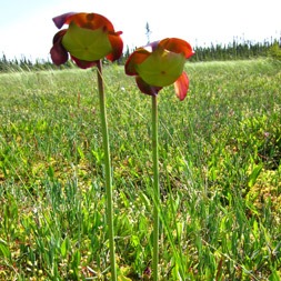
Sarracenia purpurea
(Carnivorous Purple Pitcher Plant)
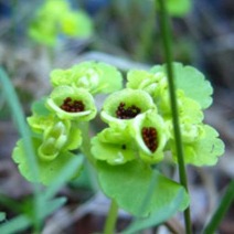
Coptis trifolia
Our Approach
The project began by developing maps that rank the probability of finding one of a suite of representative or focal species at a site. Species were selected based on rarity (using NatureServe Canada’s classification system for plant species), regional importance, and habitat type. From there, project researchers used historical detections of these focal species to query their preferred environments using several different landscape measures, including Ducks Unlimited Canada’s Enhanced Wetland Classification system, surficial geology, climate, and terrain-based indices. Based on these environmental measures, each plant’s suitable habitat and thus potential distribution was mapped across the Lower Athabasca region. Models for each of the initial target species were combined to create a single composite map highlighting the relative importance of different places for finding the target rare species.
The team uses these maps to select new sites to survey rare plants, using a standardized protocol with greater effort put towards sites predicted to have rare plant occurrences. At each site, a 0.25-hectare plot (equivalent in size to a sub-plot used within the ABMI monitoring network) is sampled to document the presence of all vascular plants, both common and rare, using a time-unlimited survey. As data are gathered from field monitoring sites, maps of rarity are adjusted to include this data and the process of selecting future sites for additional monitoring is adjusted and improved.
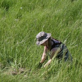
Rare plants project technician in the field.
Project Impact
The project has a number of goals, including:
- Creating a central database of target rare plant occurrences in Alberta
- Contributing information to update the conservation status of rare plants
- Understanding factors affecting rare plant populations
- Increasing efficiency in rare plant sampling and monitoring
- Informing regional land use planning
- Informing pre-development planning and mitigation, to minimize the impacts of industry on areas with high probability of rare plant occurrences
Rare plant species are often more sensitive to change in their environment than are more common plants because they have specialized ecological requirements. Using predictive maps of rarity hotspots to inform development can be an important aspect of effective land-use planning in northeastern Alberta to minimize or mitigate impact on rare species at a regional level. By building and refining maps of rare plant habitat preferences, this project is prioritizing places that are critical for the survival of rare plant species.

The ABMI works with the Biodiversity Management Framework (BMF) Science and Technical Committee within Alberta Environment and Protected Areas (EPA) to support the development of indicators for the frameworks, including those relating to species, communities, and habitat.
In 2017, we undertook a 10-year science and program review that evaluated the degree to which we delivered on our scientific goals and objectives during the first 10 years of operation.
The Peltigera project aims to expand our understanding of Peltigera lichen diversity in Alberta through genetic markers. Building on the research done by global Peltigera experts, we hope to use genetic data to both verify our identifications and detect new species to the province.
