HydroPatterns: Advancing Open Surface Water Monitoring in Alberta Lentic Ecosystems
Categories: Geospatial and Remote Sensing
Status: Completed
About the Project
Toward Alberta-wide Mapping of Lentic Open Surface Water Dynamics from Space
Alberta’s diverse lentic (i.e., standing/still) water bodies - including lakes, reservoirs, ponds, dugouts, and wetlands - vary in both time and space across the province. These water features are vital for human activities such as household use, fishing, agriculture, aquaculture, and animal husbandry. They also hold important cultural significance for Indigenous communities and cultural practices, and offer key ecosystem services, such as habitats for amphibians and migratory birds, flood mitigation, natural water filtration, and facilitating connections between surficial water and aquifers.
Reliably mapping lentic open surface water presence and its spatio-temporal dynamics across the Alberta landscape is essential for water management and wetland resource management. However, conducting frequent, on-site measurements poses substantial logistical challenges as well as high costs - it is hard to gather the regular, in-person observations needed for truly understanding monthly, seasonal, annual, and longer-term changes in inundation or flooding. Remote sensing has emerged as a useful means for consistent, broad-scale, long-term mapping of open surface water dynamics at local, regional, and global scales, to help fill these knowledge gaps. Indeed, publicly available satellite-based surface water dynamics products do exist, but currently lack intra-annual detail and fail to capture small yet ecologically important wetlands and temporary features like prairie potholes.
In this project, we developed a dataset called HydroPatterns that maps open surface water dynamics over both space and time. While similar in concept to hydroperiod, HydroPatterns has a broader focus, encompassing all lentic surface water bodies. This project addresses the limitations of existing information available on open surface water change by developing scalable, efficient, and repeatable workflows to produce monthly lentic open surface water presence maps. Details on the development of HydroPatterns are provided in this report. The resulting HydroPatterns suite of products offers finer-scale inundation metrics than what is currently available, including annual, seasonal, and multi-year inundation frequencies, as well as more spatial detail in open water extent.
The Wetland Atlas of Alberta includes a section on the Hydropatterns project which describes and tests methods for tracking open surface water presence and change over time at the landscape scale.
HydroPatterns: Advancing Open Surface Water Monitoriing in Alberta with Artificial Intelligence and Remote Sensing (YouTube).
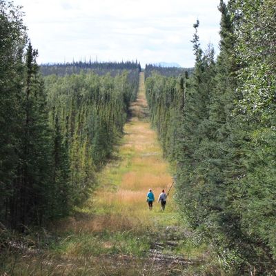
We selected two study areas that represent environments common to large portions of the Alberta landscape: one in the boreal region and one in the parkland/prairies. The boreal study area covers 604,169 hectares, encompassing Fort McMurray and Fort McKay in the Central Mixedwood natural subregion, while the prairie study area covers 517,470 hectares, encompassing Stettler and Buffalo lake in the Central Parkland natural subregion. These study areas were chosen because of their geographical overlap with recent novel and innovative wetland inventory maps (ABMI, 2024; Alberta Environment and Protected Areas, 2024).
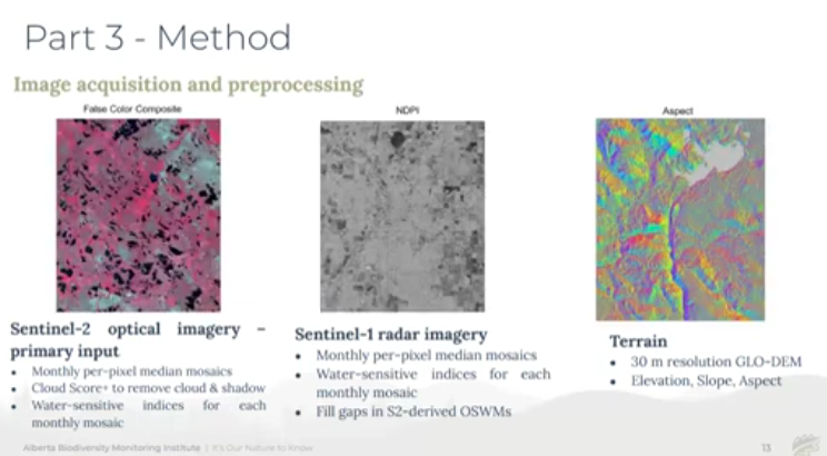
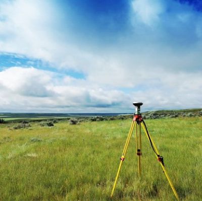
We developed and implemented a fully-automated modelling workflow in both study areas to map monthly open surface water presence at a 10 m spatial resolution during the 2020-2023 growing seasons (May to October). Our analysis primarily relied on the European Space Agency’s Sentinel-2 optical imagery, supplemented by Sentinel-1 radar imagery in cloud and shadow areas, along with topographic variables from the GLO-30 Digital Elevation Model.
Model training datasets were derived from the existing Landsat-based Canada-wide Dynamic Surface Water Maps product (Olthof and Rainville 2022) and refined using an adaptive, spectrally-based thresholding approach specific to the individual time periods over which mapping occurred. We evaluated both object-based and pixel-based modelling approaches and several machine learning algorithms to determine the most suitable strategy. Model output validation was conducted using both existing ground reference data and newly generated data. All output open water maps were post-processed using the Google Earth Engine cloud platform, with multiple quality control steps implemented to minimize misclassification errors. The resulting monthly open surface water maps were stacked to form a time series of changes in open surface water presence over the 2020-2023 growing seasons.
We calculated inundation frequency—defined as the percent time a pixel was classified as open water, ranging from 0% (never flooded) to 100% (permanent water)—on an annual (2020-2023), seasonal (spring: May - June, summer: July - August, and fall: September - October), and multi-year average basis. Additionally, monthly changes in total open surface water extent were extracted from the time series stack for each study area and plotted for visualization and further analysis.
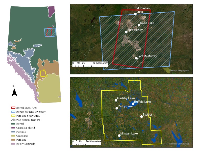
Figure 1. Map showing the location of the two HydroPatterns study areas.
"HydroPatterns is anticipated to play a key role in future ABMI wetland monitoring efforts, and may serve to further enhance future species and habitat modelling, particularly for amphibians and migratory birds."
Examples of HydroPatterns Dynamic Products

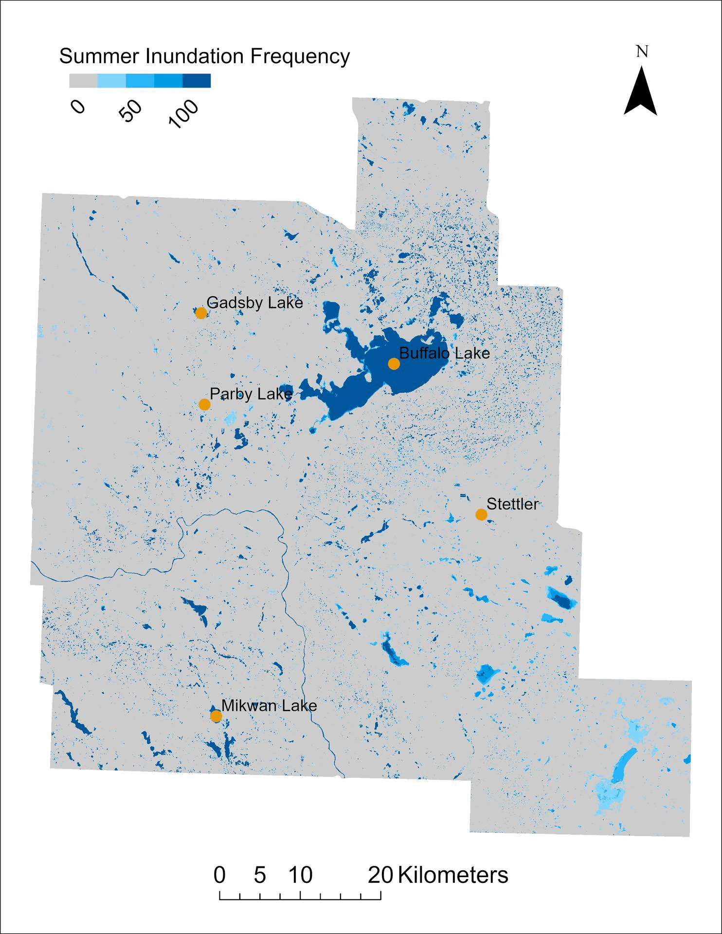
Figure 2. Annual inundation frequency in the prairie study area from 2020 to 2023.
.gif)
Figure 3. Spring, summer, and fall seasonal inundation frequency in the prairie study area from 2020 to 2023.
.jpg)
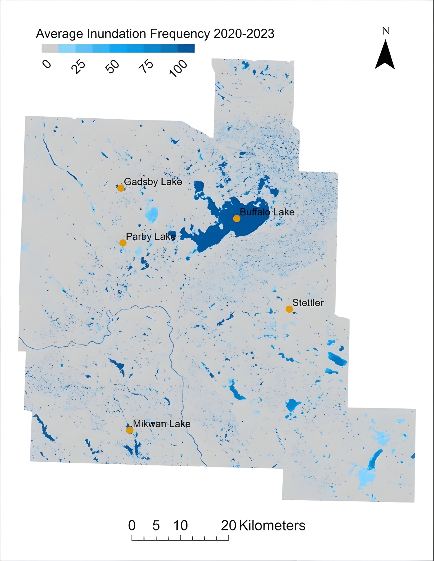
Figure 4. Four-year average inundation frequency in the prairie study area from 2020 to 2023.
What We Found
- High Accuracy Detection: The HydroPatterns workflow achieved over 90% overall accuracy in detecting open surface water presence across both study sites, aligning with the provincial mapping guidelines (Government of Alberta - Alberta Environment and Parks 2020).
- Enhanced Edge Delineation: Compared to existing Alberta-wide surface water dynamics products (DeLancey et al. 2018; Olthof and Rainville 2022), HydroPatterns offered improved edge delineation and identified a greater number of small water features (<1 ha).
- Detection of NonPermanent Water Features: HydroPatterns captured more non-permanent water features, particularly those influenced by intra-annual surface water variations, than existing products (DeLancey et al. 2018; Olthof and Rainville 2022).
- Improved Temporal Metrics: While existing Alberta-wide open surface water dynamics products primarily reflected inter-annual or multi-year trends, HydroPatterns provided both inter- and intra-annual inundation frequency metrics, along with month-to-month variations in water extent.
For more details about the HydroPatterns project and how our dataset was created, see this report (ABMI, 2025). A recorded webinar is also available for those interested in learning more about HydroPatterns.
- Regional Water Dynamics: In the boreal study area, open surface water in lentic systems remained stable throughout the study period (2020-2023). In contrast, the prairie study area experienced significant year-to-year and seasonal (spring to fall) declines in open surface water extent during this period.
- Differences in Water Stability by Lake Type: HydroPatterns revealed distinct differences in inundation frequency and water spatial stability between permanent and non-permanent lakes. While permanent lakes maintained stable open surface water presence with consistently high inundation frequencies (>80%), non-permanent lakes showed greater variability and lower average inundation frequencies (<65%).
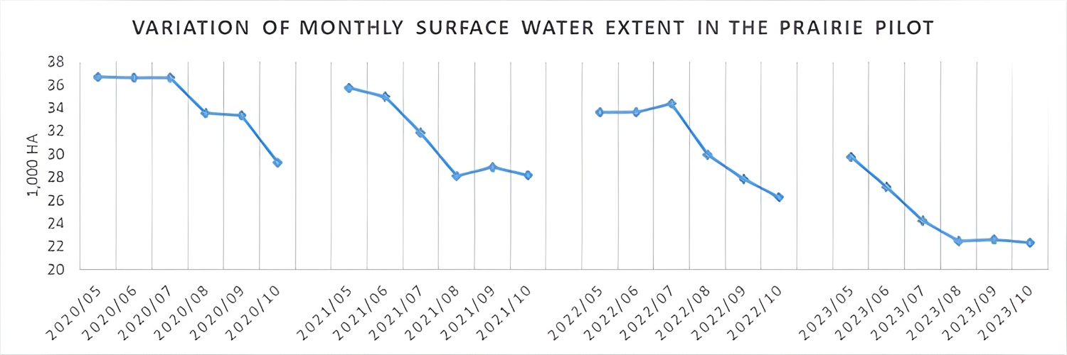
Figure 5. Variation of monthly total open surface water extent in the prairie study area from 2020 to 2023.
The development of HydroPatterns aligns with the ABMI’s 2023-2026 Strategic Plan which aims to advance the value and rigour of environmental monitoring (Alberta Biodiversity Monitoring Institute 2023). HydroPatterns is anticipated to play a key role in future ABMI wetland monitoring efforts, and may serve to further enhance future species and habitat modelling, particularly for amphibians and migratory birds.
By providing detailed open surface water dynamics for lentic ecosystems over time and space, HydroPatterns products can support a number of government, industry, ENGO, academic and other needs. These include wetland monitoring, evaluation and reporting; biodiversity monitoring and reporting; identifying unique or rare wetlands critical for conservation; flagging wetland losses and degradation and integration into land-use planning and cumulative effects management. Moreover, by enabling timely detection of open surface water dynamics, HydroPatterns supports water resource management and planning by better informing decisions on sustainable water supply and the impacts of floods and droughts.
We are now exploring opportunities to expand HydroPatterns into a province-scale product.
This project was funded by the Alberta Environment and Protected Areas.
We would like to thank Alberta Environment and Protected Areas and Ducks Unlimited Canada for their valuable input and feedback.
Alberta Biodiversity Monitoring Institute. 2023. “Alberta Biodiversity Monitoring Institute Strategic Plan: 2023–2026.”
Alberta Biodiversity Monitoring Institute. 2024. “2022/23 Wetland Inventory Program Annual Report for the Oil Sands Monitoring Program”.
Alberta Environment and Protected Area, Government of Alberta. 2024. “Project Returns for Wetland Inventory Pilots”.
DeLancey, Evan R., Jahan Kariyeva, Jerome Cranston, and Brian Brisco. 2018. “Monitoring Hydro Temporal Variability in Alberta, Canada with Multi-Temporal Sentinel-1 SAR Data.” Canadian Journal of Remote Sensing 44(1):1–10. doi:10.1080/07038992.2018.1417734.
Government of Alberta - Alberta Environment and Parks. 2020. “Alberta Wetland Mapping Standards and Guidelines: Mapping Wetlands at an Inventory Scale v1.0.”
Olthof, Ian, and Thomas Rainville. 2022. “Dynamic Surface Water Maps of Canada from 1984 to 2019 Landsat Satellite Imagery.” Remote Sensing of Environment 279:113121. doi:10.1016/j.rse.2022.113121.
Alberta Biodiversity Monitoring Institute. 2025. Webinar: HydroPatterns Advancing Open Surface Water Monitoring in Alberta [Video].
Alberta Biodiversity Monitoring Institute. Last modified Sep 19, 2025. Coarse Filter Monitoring: HydroPatterns Dataset
Alberta Biodiversity Monitoring Institute. 2025. Coarse Filter Monitoring: HydroPatterns Project Report.
This project focuses on the development of satellite remote sensing algorithms for mapping and monitoring cyanobacterial algal blooms in popular recreational lakes in Alberta.
This work will collaboratively build capacity to support land management decision-making that aligns with community priorities.
BERA focuses on understanding the effects of industrial disturbance on natural ecosystem dynamics in the boreal forest, and developing strategies for restoring disturbed landscapes in a system that is under pressure from climate change.