Monitoring the Recovery of Human Footprint
Categories: Geospatial and Remote Sensing
Status: In Progress
About the Project
The ABMI’s Geospatial Centre is working on novel methods to monitor the recovery or regeneration of human footprint features. Using the Landsat historical imagery archive (1984 to present), we have been working toward tracking and measuring the spectral regeneration of human footprint features such as harvest areas, mines, and well sites. This information is provided as a complement to our Human Footprint Inventory (HFI) where possible to provide a measure of vegetation recovery for individual features.
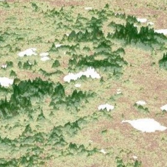
We leverage the long-running Landsat satellite image archive to capture spectral regeneration in Alberta forest harvest areas. Spectral regeneration refers to the return of spectral signals—the reflectance of light from Earth’s surfaces—to pre-disturbance conditions. As forests and vegetation communities grow and change, their spectral signatures as seen from space also change. If you can understand how changing spectral signatures relate to on-the-ground changes in a recovering forest, you have a basis for monitoring forest regeneration simply and efficiently, even over large areas like the province of Alberta.
- Forest Matters
The Human Footprint Inventory (HFI) provides comprehensive information on the location and size of human footprint features in Alberta. However, any recovery or regeneration on “temporary” footprints, such as harvest areas, is not currently incorporated into the HFI. Thus, work is ongoing to enhance human footprint data with additional information reflecting the dynamic nature of features where vegetation will regrow. Such information can provide broad-scale patterns of regeneration and regional variability, or could offer users a mechanism for the custom removal of footprint features from their maps or analyses that they consider “recovered”. Our publicly available Harvest Area Spectral Regeneration datasets include spectral regeneration information for Human Footprint Inventory harvest area polygons, where suitable (Hird et al., 2021).
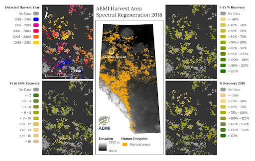
To start, the ABMI’s HFI harvest area polygons are brought into Google’s Earth Engine online, cloud-based geospatial analysis environment (Gorelick et al., 2017). In Earth Engine, Landsat imagery covering Alberta from 1984 to the time of analysis is compiled into a time series of spectral wavelengths known to be sensitive to vegetation growth, density, and health. These are processed pixel by pixel to extract information on spectral regeneration, and the outputs summarized for relevant harvest areas (e.g., those harvested within the time period). After data cleaning and quality control, the final metric summaries are added as a set of new attributes to a copy of the HFI harvest area polygons. The most recent version of the ABMI's Harvest Area Spectral Regeneration dataset is for the year 2021.
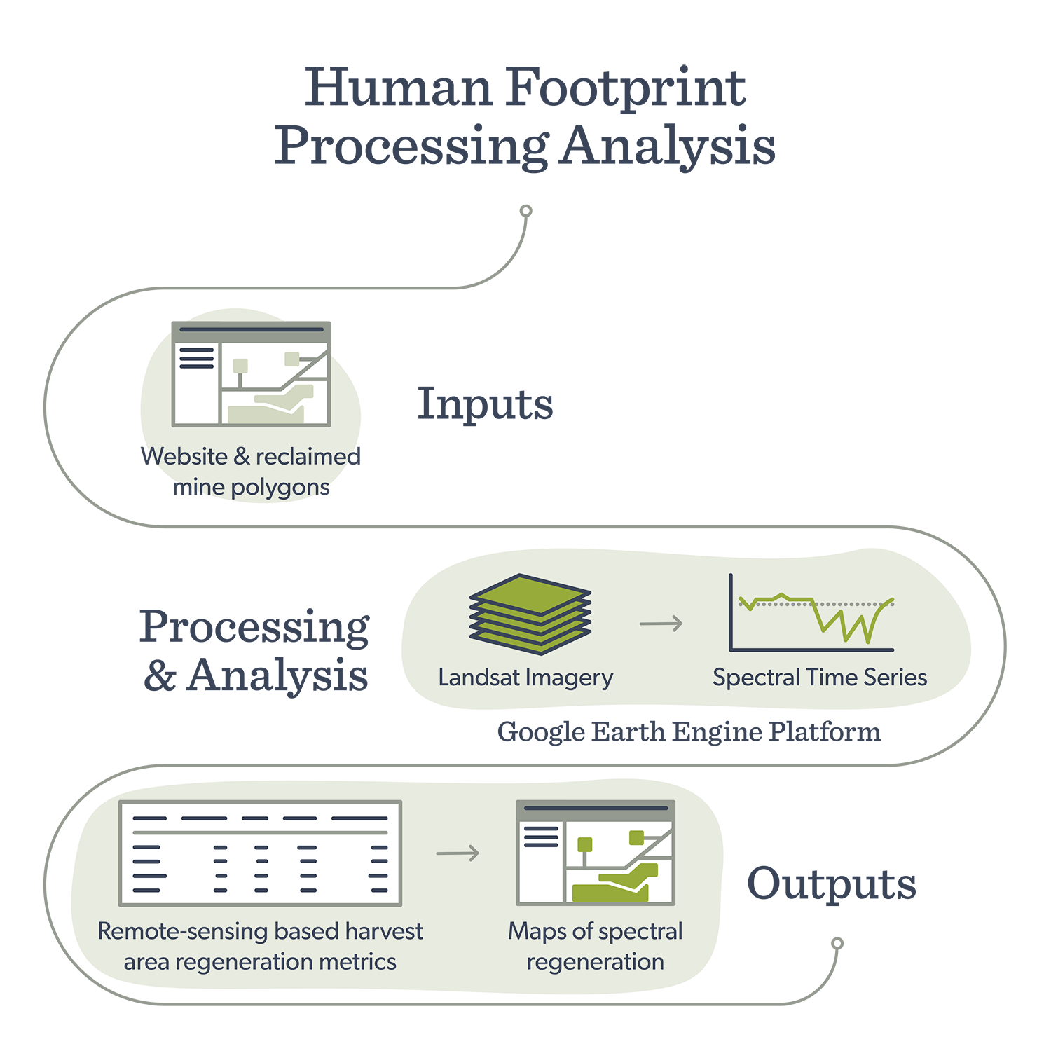
General workflow used to extract spectral regeneration information for wellsites and reclaimed mine features
Collaboration Spotlight: Forest Matters
The spectral regeneration visualization tool caught the attention of Forest Matters, a community-led citizen science group. They realized it was a perfect fit for their Ecological Recovery Project, which uses citizen observations to track the ecological recovery of local human footprints such as harvest areas. Forest Matters used the visualization tool to look at patterns of forest harvest over time, and then use this information to select ground data collection sites that cover varying ages or stages of spectral regeneration.
Once selected, survey sites were visited in person by members of Forest Matters, who collected a wide range of data on things like species presence, woody debris, tree age, and more, all based on rigorous methods that are rooted in scientific best practice. This kind of information should help to paint a more complete picture of what regenerating forests look like, and how conditions on the ground relate to what we can see from space.
As the ERP continues to collect data, the information can hopefully feed back into our understandings of recovery and how its captured in future information products.
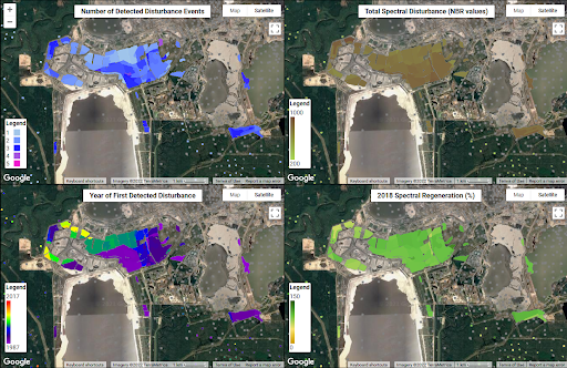
Screen capture from the visualization tool shows example spectral regeneration metrics for reclaimed mine features in the Athabasca Oil Sands.
What's Next?
Work on spectral regeneration is ongoing within the Geospatial Centre. Continued research and next steps include:
- Expansion and adaptation of the workflow and methods to other types of human footprint features. Some of this work for wellsites and reclaimed mine areas is described here.
- Exploring relationships between spectral regeneration in harvest areas and environmental conditions (e.g., climatic factors, topography).
- Pursuing opportunities for the calibration and validation of spectral-based regeneration through comparisons with various types of high-resolution remote sensing or ground-based observations.
Continued research and next steps with regard to wellsites and reclaimed mine features include:
- Refinement and expansion of the developed methods to the provincial level.
- Development of a public dataset and accompanying online visualization tool, much like what has been done for harvest areas.
- Exploration of the relationships between spectral regeneration and other geospatial information products, such as remote sensing-based land cover.
Building on the workflow developed for forest harvest area spectral regeneration, the Geospatial Centre has been working to apply these methods to other types of human footprint features. Spectral regeneration refers to the return of spectral signals—the reflectance of light from Earth’s surfaces—to pre-disturbance conditions, indicating the regrowth and increasing complexity of vegetation.
We have been focused on regeneration on wellsite and reclaimed mine features in an area surrounding the Athabasca Oil Sands (see study area map) found in the ABMI’s Human Footprint Inventory (HFI). This work is preliminary, but it shows the potential for developing remote sensing-based metrics of regeneration for other human footprint features.
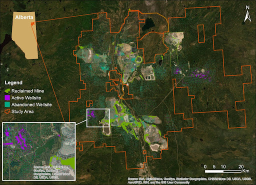
Study area map shows the location of wellsites and reclaimed mine areas in the ABMI’s Human Footprint Inventory (2018), in the area surrounding the active Athabasca Oil Sands surface mines.
- Earth Engine Virtual Meetup Presentation
Streamed live on February 10, 2021. A ~30-minute talk describing the ABMI’s harvest area spectral regeneration work, and how Google Earth Engine was leveraged to develop this product. The talk is followed by a Q & A. - Modeling Community of Practice Webinar
Posted online January 27, 2021. A ~40-minute talk outlining the details of ABMI’s harvest area spectral regeneration work, and the methods used to generate the dataset. The talk is followed by a Q & A. - Al-Pac Status of Land cover and Biodiversity Report
Research Spotlight on Spectral Regeneration. Section of an online report describing a summary of harvest area spectral regeneration results for the Alberta-Pacific Forest Industries FMA area. - Google’s Geo for Good Lightning Talk Series #7 (Forest and Nature)
Streamed live on January 27, 2022. A five-minute talk on ABMI’s spectral regeneration work, with a focus on its application to wellsites and reclaimed mine areas (talk starts at the 25:42 mark on the video). All talks are followed by a group Q & A.
This project focuses on the development of satellite remote sensing algorithms for mapping and monitoring cyanobacterial algal blooms in popular recreational lakes in Alberta.
This work will collaboratively build capacity to support land management decision-making that aligns with community priorities.
BERA focuses on understanding the effects of industrial disturbance on natural ecosystem dynamics in the boreal forest, and developing strategies for restoring disturbed landscapes in a system that is under pressure from climate change.
