ABMI Releases Historical Orthophotos of Alberta: New Insight into Alberta’s Changing Landscapes
Thanks to historical aerial photography and contemporary data analysis, Alberta now has a unique insight into the character of Alberta’s landscapes and townscapes over half a century ago. Historical orthophotos of Alberta (circa 1950-60) are now being released to the public for the first time through the efforts of the ABMI’s Geospatial Centre and its collaborating partners. This visual dataset provides a historical baseline for land use in this province, and will facilitate the measurement of change in land use since the 1950s.
“It’s expected that the value of this product will go far beyond its original purpose and intent. Having baseline data [provided by the historical orthophotos] in addition to current information enables the ABMI to understand changes on the landscape driven by the human development activity, as well as natural landscape dynamics.” -- Jahan Kariyeva, Director, ABMI Geospatial Centre
Putting this resource together was not without challenges for the ABMI; the process was an arduous one beginning in 2008, and just coming to completion this year. Initially, the task involved locating all the available imagery. Alberta Tourism, Parks and Recreation provided the original orthophotos, with the exception of 20 tiles, which were ultimately located by Alberta Environment and Sustainable Resource Development. All the images needed to be scanned, which was primarily completed by Alberta Innovates Technology Futures (formerly the Alberta Research Council) in conjunction with the University of Alberta map library. ABMI completed this process in 2015 after the missing tiles were obtained. Once the photos and negatives were scanned, the imagery was georeferenced (georeference: to associate something with locations in physical space) by the ABMI. And, finally, the ABMI completed an analysis of the positional accuracy of the imagery.
Despite the challenge, Jahan Kariyeva, Director of ABMI’s Geospatial Centre sums up why the Institute has invested a great deal of time and effort into this product. “Now the full potential of this historical imagery of our province can be unlocked and used by numerous applications and users,” says Kariyeva. “It’s expected that the value of this product will go far beyond its original purpose and intent. Having baseline data [provided by the historical orthophotos] in addition to current information enables the ABMI to understand changes on the landscape driven by the human development activity, as well as natural landscape dynamics.”
An enhanced understanding of landscape dynamics in the past century will directly support ABMI’s mission to track changes in Alberta’s wildlife and their habitats. To that end, going forward the ABMI plans to use this largely untapped data to create a historical baseline of land use, as well as to establish a reference state of land cover in Alberta from over sixty years ago.
For more information and to download the data click here.
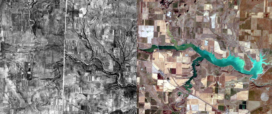
Photo: Old Man River Dam in 1949-51 (left) and 2013 (right)